


Lawyer with 15 years of legal experience, specialization: family and civil law, inheritance, contract law, criminal cases, administrative cases, cases involving foreigners, migration law
Land surveying is an important part of the land cadastres process, ensuring accurate determination of land boundaries and compliance with legal requirements. In Ukraine, the process of land plot marking is regulated by a number of legal acts that set out the procedure for conducting geodetic surveys, determining and fixing the boundaries of land plots.
Procedure for land plot marking
The process of land plot marking includes several stages:
- Preparatory stage: Collection of the necessary documents: title documents for the land plot, technical documentation and other documents confirming the right of ownership or use.
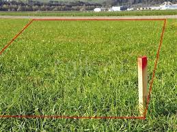
Conclusion of a contract with a geodetic organisation licensed to carry out such work. - Field work: Establishing the boundaries of the land plot on the ground using geodetic instruments.
Marking of boundary markers on the ground in accordance with the technical documentation. - Camera work: Processing of data obtained during fieldwork.
Preparation of technical documentation on land management, including a plan of the land plot boundaries, an act of approval of the boundaries with neighbouring land users and other necessary documents. - Approval of the land plot boundaries: Approval of technical land management documentation with the relevant authorities.
Obtaining a conclusion on the compliance of the technical documentation with the requirements of the law. - Entering data into the State Land Cadastres: Submission of documents to the territorial office of the State Geocadastre.
Entering information on the boundaries of the land plot into the State Land Cadastres.
Legal aspects and requirements
In accordance with the applicable law, the land plot marking must meet the following requirements:
- Accuracy of the boundaries: The boundaries of the land plot must be determined with high accuracy, in accordance with the standards of geodetic work.
All boundary markers must be installed in accordance with the project documentation. - Coordination of boundaries with neighbouring land users: The owner or user of a land plot is obliged to agree on the boundaries with neighbours.
A signed act of boundary approval is a mandatory document for the approval of technical documentation. - Compliance with environmental standards: The markings must take into account environmental standards and restrictions established by law.
Particular attention is paid to the marking of land located in nature protection zones or having a special environmental status. - Liability for violation of marking rules: Violation of the established requirements for land marking may result in administrative liability.
Fines and other penalties are imposed for non-compliance of technical documentation with legal requirements, as well as for unlawful installation of boundary markers.
Marking the boundaries of the site is a complex and important process that requires accuracy, compliance with legal requirements and coordination with neighbouring land users. Compliance with all legal aspects during the marking process ensures not only the legal purity of the process, but also helps to preserve the rights of landowners and users. Site marking price, marking the boundaries of the land plot, marking the territory of the land plot.